Sunday was a dreary winter day with temperatures holding steady in the lower 50’s most of the day.
The latest radar sweep showed rain moving into the state from Louisiana. Look for this trend to continue. Rain and isolated thunderstorms are possible through Tuesday night, with the heaviest rainfall projected for Tuesday.
A look at the long-range weather pattern continues to show signs of an artic air intrusion, but to what extent and for how long, is still up for debate. These signs include:
The Arctic Oscillation is starting a downturn
(from Dr. Ryan Maue’s website policlimate.com)
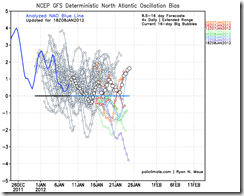
The NAO is going negative too…
If we are going to get any sustaining cold events, those two puzzle pieces need to be in place. Also, the SSW (Sudden Stratospheric Warming) that was talked about in a previous post is recharging with a renewed vigor.
Three important pieces if you are going to have a major outbreak this far south. A missing component?
Current Snow Cover
Snow cover to our north. Without sufficient snow cover across the Midwest, any arctic air that may visit will likely be modified arctic air. There is a chance the next two or three fronts that make their way across the plains could leave behind some snow.
So the big question is, will the SEARK region be getting any wintry precipitation? I believe our chances will increase toward the latter part of January or early February.


No comments:
Post a Comment